

In a world where infrastructure needs are rapidly evolving, traditional methods of design and planning are no longer enough. Roads, bridges, railways, water systems, and utilities now face the pressures of growing populations, environmental concerns, tighter budgets, and stricter regulations. To keep up with this complexity, the industry is turning to BIM in infrastructure design—a digital approach that’s redefining how civil projects are planned, designed, constructed, and maintained.
Once associated mainly with vertical construction, Building Information Modeling (BIM) has become a powerful tool in the horizontal and civil infrastructure sectors. From concept to completion and beyond, BIM in infrastructure design empowers engineers, architects, contractors, and owners to collaborate in a virtual environment that mirrors the real world.
What Is BIM in Infrastructure Design?
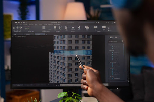
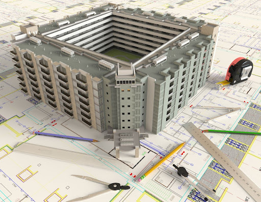
BIM in infrastructure design refers to the use of intelligent 3D models and data-rich digital representations to plan, simulate, and manage infrastructure projects. Unlike traditional CAD tools, which create isolated drawings, BIM provides an integrated model that includes geometry, spatial relationships, geolocation data, materials, and lifecycle information.
These models allow users to:
- Visualize entire infrastructure networks in 3D
- Simulate construction phasing and logistics
- Coordinate multidisciplinary designs
- Detect potential conflicts early
- Plan operations and maintenance with greater precision
Whether it’s designing a highway interchange, laying down underground utilities, or coordinating a transit hub, BIM in infrastructure design enables smarter decisions, fewer errors, and more efficient project execution.
Benefits of BIM in Infrastructure Design
The benefits of BIM extend far beyond better visuals. It fundamentally reshapes how infrastructure is conceived, built, and maintained.
1. Enhanced Collaboration Across Stakeholders
Infrastructure projects typically involve a wide range of players—civil engineers, transportation planners, utility companies, environmental consultants, and public agencies. BIM acts as a central hub, allowing all stakeholders to work from a shared model. Real-time updates, cloud integration, and collaborative platforms reduce miscommunication and keep everyone aligned.
2. Accurate Visualization and Simulation
BIM in infrastructure design allows planners to visualize road gradients, drainage flows, bridge clearances, and terrain interactions before breaking ground. With 4D BIM, designers can simulate construction sequencing, helping teams identify risks, optimize schedules, and manage space constraints on busy sites.
3. Early Clash Detection
One of the most valuable aspects of BIM is clash detection. In large-scale infrastructure projects, avoiding utility conflicts, structural overlaps, or right-of-way encroachments can save thousands—or even millions—of dollars. The BIM model highlights clashes early, allowing design teams to resolve them before construction begins.
4. Better Cost and Schedule Management
By integrating scheduling (4D) and cost data (5D) into the model, BIM in infrastructure design gives teams a clear understanding of how design changes impact budget and timelines. Project managers can analyze different scenarios and make informed decisions to avoid cost overruns or delays.
5. Lifecycle Asset Management
BIM doesn’t end at construction. It continues to serve as a “digital twin” of the infrastructure asset. Municipalities and agencies can use the model to schedule inspections, manage maintenance, track asset performance, and plan future upgrades—all based on a reliable digital foundation.
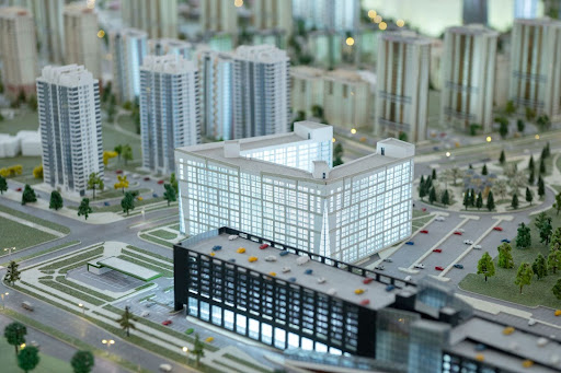
Real-World Applications of BIM in Infrastructure Design
Across the globe, BIM is driving innovation in public works and infrastructure development. Some notable applications include:
- Transportation Projects: Departments of Transportation (DOTs) in the U.S. and abroad are increasingly adopting BIM to manage complex highway expansions, rail corridors, and intermodal transport systems. For example, the California High-Speed Rail project has leveraged BIM to manage coordination among dozens of contractors across thousands of components.
- Water and Sewer Networks: Utilities are using BIM in infrastructure design to plan water distribution networks, wastewater systems, and stormwater management systems. The models help simulate flow dynamics and optimize maintenance access points.
- Airports and Transit Hubs: With their intricate web of runways, terminals, baggage systems, and underground utilities, modern airports rely on BIM for coordination, expansion planning, and emergency response simulation.
- Bridges and Tunnels: BIM facilitates the integration of structural, geotechnical, and environmental data, making it easier to design safe, efficient, and sustainable bridge and tunnel systems.
Integrating BIM with GIS and Emerging Tech
A major advancement in BIM in infrastructure design is its integration with Geographic Information Systems (GIS). GIS provides spatial context—land use, zoning, topography, and environmental data—while BIM offers detailed design and construction information.
Together, they enable:
- Smarter site selection
- Better environmental impact analysis
- Real-time field data integration
- Smarter city planning
BIM is also merging with other technologies such as:
- IoT sensors for real-time monitoring of asset performance
- Drones for site surveys and progress tracking
- AR/VR for immersive design reviews and safety training
- AI and machine learning for predictive maintenance and design optimization
Challenges to BIM Adoption in Infrastructure
Despite its benefits, there are still barriers to adopting BIM in infrastructure design:
- Lack of standardization: Unlike vertical construction, civil infrastructure lacks consistent BIM standards across jurisdictions.
- Resistance to change: Many organizations still rely on legacy CAD-based workflows and are slow to embrace digital transformation.
- Training gaps: Skilled professionals trained in traditional design methods may need extensive upskilling to use BIM effectively.
- Data management complexity: BIM models are data-rich and can become unwieldy without proper management systems.
However, these challenges are gradually being overcome as public agencies start to mandate BIM on public projects, and software platforms become more interoperable and user-friendly.
Future Outlook
The future of BIM in infrastructure design is one of integration, intelligence, and insight. As digital twins, smart cities, and AI-driven design become mainstream, BIM will serve as the foundation for this interconnected infrastructure ecosystem.
We can expect:
- Greater automation in design workflows
- Seamless interoperability with construction and asset management systems
- Real-time data feedback from infrastructure assets via IoT
- Continued convergence of BIM, GIS, and geospatial analytics
Paper Plans? So Last Century—BIM Is the Real MVP
BIM in infrastructure design is more than just a trend—it’s a paradigm shift. It transforms the way infrastructure is planned, built, and maintained by fostering collaboration, improving accuracy, reducing risk, and supporting long-term sustainability.
For project owners, engineers, and public agencies, adopting BIM means moving from reactive problem-solving to proactive project leadership. And as infrastructure becomes smarter and more interconnected, BIM will be the digital backbone of the systems that move us, power us, and protect us.
Now is the time to build the future—with BIM at the core.